Landscapes & Road Trips History & Concepts Motorcycling Road Trips:
Los Alamos and Chaco Canyon trip recap#
Posted 2025-06-14
I loved this trip! It was a 1045 mile sojourn that epitomized the vast range of destinations, sights, environs, and "pathways" that New Mexico and Colorado offer up to a motorcycling wanderer -- particularly one on a crossover/adventure-touring motorbike willing to roll on past the signs warning of miles of unpaved, unimproved roads ahead.
A collection of facts that attest to the variety and expanse of this trip:
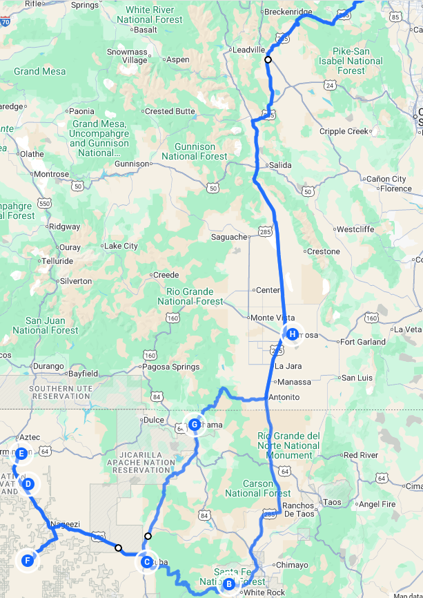
- Mountain passes crossed:
- Kenosha (10,000 ft)
- Poncha (9,010 ft)
- Cumbres (10,022 ft)
- "Adventure" roads traversed:
- New Mexico State Road 126
- New Mexico State Road 112
- It might be fair to count CR 7950 to Chaco Canyon here, many miles of which are unpaved and occasionally adversarial
- National Forests crossed:
- Pike
- San Isabel
- Rio Grande
- Carson
- National Park Service venues visited:
- Bandelier National Monument
- Manhattan Project National Historical Park - Los Alamos site
- Chaco Culture National Historical Park
- Continental Divide crossing:
- near Cuba, NM - US 550
- Reservation lands traversed:
- Jicarilla Apache Nation
- Navajo Nation
- Altitude range:
- Highest - Cumbres Pass 10,022 ft
- Lowest - ~ 6,100 ft in the case of both the Tyuonyi archeological site at Bandelier and of the Chaco Canyon loop road
I squeezed in a moderate amount of hiking at Angel Peaks Badlands and at Chaco Canyon and also walked the Pueblo Loop Trail at Bandelier National Monument to marvel at its principal archeological sites. The downtown Los Alamos walking tour is a treat for anyone who has delved into accounts of the Groves/Oppenheimer WWII development period that lead to the Trinity test and to the engineering of the Little Boy and Fat Man atomic bomb platforms. The Bradbury Science Museum, also in downtown Los Alamos, is a small but wonderfully-conceived museum covering both the science history of the Manhattan Project and the full sweep of scientific advances of the Los Alamos Labs up through the present.
Of the brooding hail storm that greeted me near the New Mexico state line on day one, I thank it for kindly waiting until about 90 seconds after I got my raingear on to let loose. It's never good to see US 285 virtually blanketed in pebble-sized hail as you are slowly, cautiously attempting to ride out of the fray.
Below are a few of my pictures that hint at the rich sights and wonders of this journey.

The Blackbird (2018 Kawasaki Versys 650LT) at Collegiate Peaks Overlook

View of Tyuonyi pueblo ruins from Talus House (Bandelier National Monument)

Typical view traveling US 550 between Cuba and Nageezi

Looking down into Angel Peak Badlands

Chaco Canyon's Fajada Butte

The Una Vida petroglyphs (Chaco Culture NHP)

The Kin Kletso great house (Chaco Culture NHP)

A view travelling NM 112 (miles of which is unpaved and angles across the Jicarilla Apache Nation)
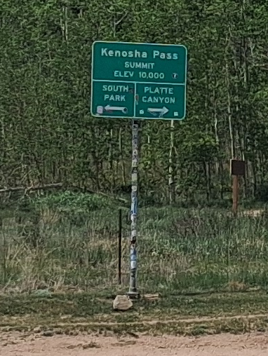
Humble sign atop Kenosha Pass indicating awesome things to behold down either side (and to weave down via motorcycle)
Leave a comment
Submissions are subject to review and approval